

By Brent Bellamy, Creative Director and Architect
Republished with permission courtesy of the Winnipeg Free Press.
Winnipeg’s rivers have divided its neighbourhoods since the days when St. Boniface was an independent city with ferry service to the English side of the river. The physical segmentation of Winnipeg, by rivers and railyards, has made it a city of unique neighbourhoods. Communities that are geographically adjacent, but without direct pedestrian connections, have often developed with a distinct character, demographic, economy and history.
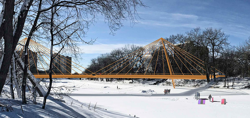
Image: Supplied
One of the preliminary designs for a pedestrian bridge over the Assiniboine River to connect Osborne Village to downtown via McFadyen Park and Fort Rouge Park.
Winnipeg’s rivers have divided its neighbourhoods since the days when St. Boniface was an independent city with ferry service to the English side of the river. The physical segmentation of Winnipeg, by rivers and railyards, has made it a city of unique neighbourhoods. Communities that are geographically adjacent, but without direct pedestrian connections, have often developed with a distinct character, demographic, economy and history.
Designed primarily to funnel people through neighbourhoods, and not be connectors between them, the city’s many vehicular bridges have had limited success breaking down the traditional divisions between Winnipeg’s communities. A new pedestrian and cycling bridge, however, proposed to span the Assiniboine River and connect the cycling infrastructure of Osborne Village and downtown, might present a new model to effectively link many of Winnipeg’s communities at a more intimate scale.
As always, there is public debate about the cost and details, but the new bridge represents an important opportunity to change the dialogue about mobility in Winnipeg. Done well, it can be a symbol of a progressive and inclusive city that is broadening its transportation options. Calgary’s similar Peace Bridge, designed by renowned Spanish architect Santiago Calatrava, has become a postcard image, representing a forward-looking city. There may be other bridges with shoulders and sidewalks for cyclists and pedestrians, but a dedicated crossing changes the experience of those activities and by giving them priority, elevates the value of active transportation in the city and attracts more users.
With construction costs of about 10 per cent that of a car bridge, cycling and pedestrian bridges could affordably be replicated in strategic areas across the city, introducing a new network of connectivity between Winnipeg’s divided neighbourhoods. This web of active mobility could link communities together and potentially change how we define our neighbourhoods. It could transform how we move around our city, increasing economic opportunity, neighbourhood vibrancy and quality of life.
Uniting communities through active transportation could grow neighbourhood economies by reducing pedestrian distances and expanding the potential market for local shops, restaurants and services. With a well-located pedestrian bridge, shops on Westminster Avenue would be a nine-minute walk (800 metres) from the shops on Academy Road in River Heights. The Osborne strip could be a seven-minute walk from Norwood Flats, or a 10-minute walk to the shops on Sherbrook Street. Most people in River Heights wouldn’t drive to the Tall Grass Prairie Bread Company in Wolseley, but they might take a 10-minute walk, or four-minute bike ride, over the river on a quiet bridge.
Studies in other cities have shown that housing located near active transportation networks that provide access to these types of amenities can realize an increase in property values. Greater community integration might also help elevate the value of housing in newly connected, adjacent lower-income neighbourhoods.
Another important benefit to increased mobility options is to help provide opportunity for those who might not have access to a personal vehicle. Improved active transportation connectivity can increase social inclusion by expanding access to schools, employment, food options, retail, and recreation opportunities. With pedestrian bridges, the University of Manitoba could be a 10-minute walk from St. Mary’s Road. Whittier Park could become a directly accessible green space for residents of Point Douglas and the Exchange District.
Connecting neighbourhoods and reducing pedestrian and cycling distances create social opportunity by increasing access to a wider number of public transit routes, reducing commuting times and effectively widening the catchment area within which a transit user could reasonably commute to work or school. More convenient access to transit through better pedestrian connections would help both inner-city and suburban residents. A bridge between Westwood and Charleswood, as an example, would effectively double the number of transit routes accessible with a five-minute walk between Assiniboine Avenue and Roblin Boulevard. The same potential can be found between Henderson Highway and Main Street, or Osborne Street and St. Mary’s Road. With the average Canadian family spending almost 20 per cent of their household income on vehicle ownership, any reduction in driving costs could have an important impact on quality of life, even for more affluent suburbanites.
Another new development in Winnipeg’s active transportation infrastructure could help extend this idea of connectivity between neighbourhoods. Traditionally, bike lanes have only been included in major road renewal projects, which has made their implementation extremely slow. A new lane on Garry Street downtown, for instance, will take three years to be complete as part of a much larger reconstruction project.
Over the winter, the city ran a pilot project of pre-cast concrete curbs that are significantly less expensive and easier to install. They tested things such as drainage, functionality and durability against snow clearing. With the success of the pilot, construction is now beginning on a four-kilometre protected bike lane connecting the West Alexander neighbourhood (Health Sciences Centre) with Waterfront Drive in the Exchange District. The system will be completed in 12 weeks at a fraction of the cost of traditional curbs.
This exciting new mindset on bike lane construction could mean much faster and less expensive implementation of cycling infrastructure, connecting Winnipeg neighbourhoods to each other and to downtown.
It is an exciting time for active transportation in Winnipeg. We have fallen behind other cities but are now poised to catch up. Introducing an intimate new layer of human-scale mobility and connectivity across Winnipeg’s neighbourhoods could transform how we move around the city and help to create more vibrant, inclusive and healthy communities.
Brent Bellamy is chairman of CentreVenture’s board and the creative director at Number Ten Architectural Group.
bbellamy@numberten.com